Dartmouth Road, again!

The History of Sydenham from Cippenham to present day. Links to photos especially welcome!
Post Reply
Falkor
Posts: 1371
Joined: 10 Feb 2006 17:45
Location: Surrey Quays

Dartmouth Road, again!

Post by Falkor »

Image

1) I noticed there's a small park here (I visited there once when I was really young). Anyone know anything about the history of this park? Could it be undeveloped land left over from the Market Gardens (now mostly covered by the Swimming Baths), or even Sydenham Common?

2) Was this a small parade of shops, down the middle of Dartmouth Road, next to the old church?
Steve Grindlay
Posts: 606
Joined: 4 Oct 2004 05:07
Location: Upper Sydenham

Post by Steve Grindlay »

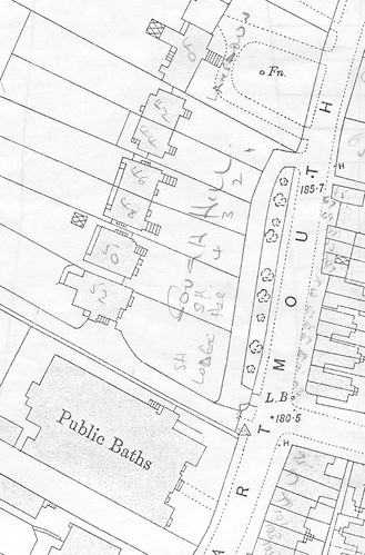
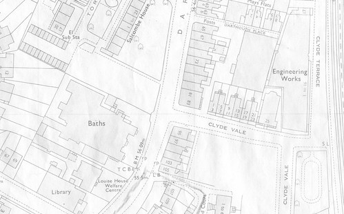
Falkor, as far as 1) is concerned, I believe your rectangle should be slightly north, so that it encloses the house and its grounds just above it. That is the plot that was to become the small park. These two maps show what I mean.
This is dated 1894:
Image

and this is dated 1970:
Image

The house was called South Hill Lodge and was later numbered 52 Dartmouth Road. The other houses (nos.42-50) were on the site of Salcombe House. The 1970 map shows a small park at the bottom of Clyde Vale. This was lost when the business centre was developed, and the plot next to the pools was intended to compensate for this loss.

The Market Gardens belonged to St Bartholomews (awarded to the church when the Sydenham Common was enclosed). The vicar let allotments to those parishioners who would otherwise have no land, so that they could grow food. Over time, parts of this plot were made available for buildings that would benefit the community (school, swimming pools, industrial home and library). During the 1930s the part of this land furthest from Dartmouth Road was sold for housing.

I can't say much about your second question other that that it was a terrace of small shops. Although I don't have a picture of them, this is a rather nice on of the chapel (on the site of the entrance to Suncroft Place) with the last shop of the terrace just visible on the left.
Falkor
Posts: 1371
Joined: 10 Feb 2006 17:45
Location: Surrey Quays

Post by Falkor »

Cheers for posting the large-scale maps and information; much appreciated!
The 1970 map shows a small park at the bottom of Clyde Vale. This was lost when the business centre was developed, and the plot next to the pools was intended to compensate for this loss.
Now, that's something I would never have known about... I don't think I've ever been down that road, apart from passing by via. dog poo alley; might have to do some exploring when it becomes light at 6 again.
I can't say much about your second question other that that it was a terrace of small shops. Although I don't have a picture of them, this is a rather nice on of the chapel (on the site of the entrance to Suncroft Place) with the last shop of the terrace just visible on the left.
Wow, that's a nice photo! Super duper quality as we've come to expect from Steve's standard... The most intrigueing thing is the shops on the right at the junction with Willow Way, next to the old Police Station, with the pub on the opposite corner. In Steve's other photo of the Police Station, the corner shops had already been demolished to make way for what is now the current Police Station building. The terrace of houses in the middle still survives, set a little back from the road, at the edge of what was the Croydon Canal Reservoir (it's boundary followed the side of Dartmouth Road and Willow Walk).

Everytime I walk down the bottom of Dartmouth Road, I'm always fascinated to think that I'm actually walking between the site of the former Croydon Canal and one of the canal feeders.
zozo
Posts: 24
Joined: 19 Dec 2005 12:51
Location: Kent Coast

Post by zozo »

Hi

This is fantastic - I have been trying for years to find out any info I can about the chapel on the corner of what is now Suncroft Place. I had begun to think I had dreamt the place up. My nan told me about it years ago as it was next door to the house our family lived in for years. I have seen the chapel on maps but can't seem to track down any solid info on it.

Unfortunately I can't seem to find the pic of the chapel Falkor and Steve refer to in this thread either - am I missing something?

Just wondering also if there would be any records in existence for this chapel? Presumably they'd be accessible at Lewisham Local Studies library.

Also I thought the Croydon Canal reservoir lay at least a hundred yards or so back from Dartmouth Road. I knew Willow Way was so called as it contained an avenue of willows bordering the reservoir. But from what you say though it seems the reservoir pretty much came right up to what is now the tarmaced road surface of Dartmouth Road and followed that road right up to the corner of Sydenham Park Road. Is that correct?

zozo
Steve Grindlay
Posts: 606
Joined: 4 Oct 2004 05:07
Location: Upper Sydenham

Post by Steve Grindlay »

Hi Zozo

This is a direct link to the picture. If you click on "ALL SIZES" you can get an enlarged view:
http://farm1.static.flickr.com/141/3698 ... 17cc_b.jpg

The reservoir was created in about 1809 and Dartmouth Road and Willow Way were created during the 1820s, following the edge of the canal. If you walk along Sydenham Park Road, from the junction with Dartmouth Road, you can see that the road slopes down. Continue past the junction with Sydenham Park and Whittell Gardens to the point where the road rises. You have now crossed the reservoir - the dip and the rise are the opposing banks. Although much of the reservoir was filled in, there are a few clues. The difference in ground level between the garden of 2 Sydenham Park Road and Dartmouth Road is one example.

Local Studies may well have some information about the chapel. I know that the church was built about 1862 and after World War 2 became some sort of store for telephone equipment, before being demolished.
zozo
Posts: 24
Joined: 19 Dec 2005 12:51
Location: Kent Coast

Post by zozo »

Oh my goodness thank you - you have made my month with that photo!

My mum will also be thrilled to see that pic. It looks like it was taken around the first decade or so of the 20th century - is that about right?

Do you know when the terrace of houses next to the chapel was built by any chance? That's another thing I've being trying to find out and have come up with about three dates so far. It looks from the map above like the terrace was originally called 'York Terrace'.

I have been trying to find out who lived in the house before my family moved in at the end of the 19th century as the place had an 'odd' feel to it (!) My great grandma apparently put it do to the bloke who lived there before the family moved in - she claimed he died there. She reckoned he worked in the chapel next door. Who knows? I just thought it would be fun to find out if her story had any truth behind it. It's been difficult as the numbers of the houses themselves have changed in that time - and even the name of the road itself from High Street to Dartmouth Road.

Also, I belive there used to be some old cottages at the back of the chapel where Suncroft Place now stands. My great aunty Mary used to go and help lay people out down there after they had died. As far as I know uou don't get that any more in Sydenham...

Thanks again for the fantastic picture!
Steve Grindlay
Posts: 606
Joined: 4 Oct 2004 05:07
Location: Upper Sydenham

Post by Steve Grindlay »

zozo wrote:Do you know when the terrace of houses next to the chapel was built by any chance? That's another thing I've being trying to find out and have come up with about three dates so far. It looks from the map above like the terrace was originally called 'York Terrace
They were probably built about 1847 and two or three of them were still unoccupied in 1851. As you say, they were originally 1-6 York Terrace. In the 1880s they became 116-126 High Street and in the 1930s were renumbered again to become 165-175 Dartmouth Road. If the house your family lived in was next to the chapel (no.165) it would have been 6 York Terrace and 126 High Street. Henry Green, a fishmonger and poulterer, was living there at the end of the 19th century. If this was the house, and you have a bit more information (dates and names) I might be able to fine more information. PM me if you prefer.

The cottages where Suncroft Place is were called Hamburgh Place.
Falkor
Posts: 1371
Joined: 10 Feb 2006 17:45
Location: Surrey Quays

Post by Falkor »

Interesting info... I wonder how the c1847 date of York Terrace compares with the building date of the other surviving, smaller terrace, on the other side of Suncroft Place? :)
Falkor
Posts: 1371
Joined: 10 Feb 2006 17:45
Location: Surrey Quays

Original photo is blurred unfortunately...

Post by Falkor »

Image
Steve Grindlay
Posts: 606
Joined: 4 Oct 2004 05:07
Location: Upper Sydenham

Post by Steve Grindlay »

Falkor wrote:... I wonder how the c1847 date of York Terrace compares with the building date of the other surviving, smaller terrace, on the other side of Suncroft Place?
Very similar, I would say. Both terraces were developed as part of the Sydenham Park estate (originally the name was applied to the whole development within the drained reservoir). York Terrace appears on the 1843 Tithe Map, but only in outline. This suggests that it was being planned as early as this, if not actually under construction.
Falkor
Posts: 1371
Joined: 10 Feb 2006 17:45
Location: Surrey Quays

Nice

Post by Falkor »

Some photos of the other terrace from 1970...
Image

Image
Iggypiggy2
Posts: 2
Joined: 6 Jun 2007 00:02
Location: Hove, East Sussex

My Great Grandmother and her illigitimate son lived there!

Post by Iggypiggy2 »

My Great Great Grandmother Delphine lived in Hamburgh/Suncroft Place in the late 1800's with her son born out of wedlock called Arthur.

There was definately a chapel there and and the road was called Hamburgh and later named Suncroft. Delphine was a single mother and the people connected with the church are listed as her witnesses when she later married. She is also shown on the census as living with the Piggott family.

John Causley (who was described in one census as a bootmaker and preacher) was at 3 Hamburgh Place in 1871 and by 1881 he had moved to no.1. He died there in 1892

My Great Grandmother lived with the Piggott family and they helped her when she was a single mum with her first son. I believe they where fosterers/wet nurses..

Henry Piggott's parents came to Sydenham in about 1847 and by 1861 (when Henry was 7) they were at 6 Hamburgh Place. Henry was at no.2 in 1891, but by 1894 he was at no.1. He died there in 1926 and his widow, Alice, was still there in 1939[/list]
Iggypiggy2
Posts: 2
Joined: 6 Jun 2007 00:02
Location: Hove, East Sussex

Help in adding images

Post by Iggypiggy2 »

I have some census returns to add to my message.
How do i attach these please?

Lucy[/img][/list][/url]
Eadefamily
Posts: 9
Joined: 1 Jul 2010 23:12
Location: Sussex

Next door to my family too?

Post by Eadefamily »

My family lived at 1 Hamburgh Place which was later named Suncroft and i was led to believe this too was next to the chapel? What is your family surname? My Great Grandfathers sister May Eade lived there and later married someone called William Miles. I wonder if May and William are your relatives?

quote="zozo"]Hi

This is fantastic - I have been trying for years to find out any info I can about the chapel on the corner of what is now Suncroft Place. I had begun to think I had dreamt the place up. My nan told me about it years ago as it was next door to the house our family lived in for years. I have seen the chapel on maps but can't seem to track down any solid info on it.

Unfortunately I can't seem to find the pic of the chapel Falkor and Steve refer to in this thread either - am I missing something?

Just wondering also if there would be any records in existence for this chapel? Presumably they'd be accessible at Lewisham Local Studies library.

Also I thought the Croydon Canal reservoir lay at least a hundred yards or so back from Dartmouth Road. I knew Willow Way was so called as it contained an avenue of willows bordering the reservoir. But from what you say though it seems the reservoir pretty much came right up to what is now the tarmaced road surface of Dartmouth Road and followed that road right up to the corner of Sydenham Park Road. Is that correct?

zozo[/quote]
Eadefamily
Posts: 9
Joined: 1 Jul 2010 23:12
Location: Sussex

Re: Dartmouth Road, again!

Post by Eadefamily »

I think Steve Grindlay has all the history about the chapel, a Wesley chapel which was part of the Methodist movement as John Wesley was a founder.
Eadefamily
Posts: 9
Joined: 1 Jul 2010 23:12
Location: Sussex

Re: Dartmouth Road, again!

Post by Eadefamily »

https://books.google.co.uk/books?id=of7 ... CCkQ6AEwAg

Found this link on the book by Steve Grindlay
Post Reply