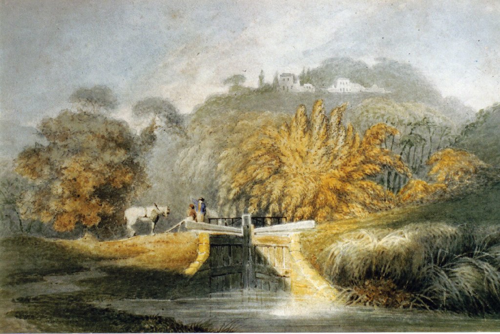
Croydon Canal route: Honor Oak Park to Brockley

The History of Sydenham from Cippenham to present day. Links to photos especially welcome!
Post Reply
will greenwood
Posts: 352
Joined: 14 Jan 2008 23:45
Location: moorlinch

Post by will greenwood »

could be right, then.
I'd imagine the towpath went with the canal.
the tow path could have been left as a right of way. if , as you said, people continued to use it, and, acted as a boundary ...
it would be interesting to see if ther e are any records of the work building the crematorium, or the general levelling of that area...(it might be related to the time of the golf club riots)
I think we could atleast try a little harmless dig into the banks beside the tennis courts.
I'm not squeamish about that...I just want to get into the cutting and have a good root about...which they might be a little sensitive about
I reckon its worth a look at garthorne rd reserve too, for that bit of embankment....it lines up perfectly with the canal

if we agree on that allignment, then , i'll measure out the rest over the weekend and see if the locks line up .
Good stuff.
will greenwood
Posts: 352
Joined: 14 Jan 2008 23:45
Location: moorlinch

Post by will greenwood »

http://farm3.static.flickr.com/2030/223 ... a334_o.jpg

oh well...that doesnt work!
ot only lines up if there are only 5 locks...
back to the drawing board
Falkor
Posts: 1371
Joined: 10 Feb 2006 17:45
Location: Surrey Quays

Post by Falkor »

Are you trying to line up the canal with the bank seen in the old photo? You may have that bank in the wrong place, as I took some comparison photos, but had trouble comparing the scene. It might be best to look at a map to find out where the golf club office and banks were located. Trying to judge the scene based on photos is just too difficult...
Image
How high up was this photo taken?

Image

Image

Image

Image

Image

It wouldn't hurt to have a dig at the side of the tennis court, since it's already quite messy down there...
Image

Image

Image

Dead Lane from the east...
Image

Image

Image

Dead Lane from the west...
Image

Image

A look at the eastern banks of the railway at Brockley Way footbridge...
Image

Image

A look at the mound on the southeastern bank of Brockley Way footbridge...
Image

Image
will greenwood
Posts: 352
Joined: 14 Jan 2008 23:45
Location: moorlinch

Post by will greenwood »

still trying to line up the triangular bit, and get the rest to fit...
I'm happy to go with the previous course....
remember , only the top part of that embankment could stoill be trhere...the rest has gone...
it wouldnt be the towpath as such, but the opposite bank...western....often both sides of a lock flight becomes usedas a towpath...
anyway
heres an old view of some similar locks...just to get a feel for it.

http://farm3.static.flickr.com/2339/223 ... a408_b.jpg

http://farm3.static.flickr.com/2385/223 ... b433_o.jpg

http://farm3.static.flickr.com/2339/223 ... 9af4_o.jpg

...as you can see from the map overlay, the hedge/embankment follows the line of the canal, downhill untill roughly lock 23, again.....

i cant wait to have a look myself..
thanks for those images....[/url]
Falkor
Posts: 1371
Joined: 10 Feb 2006 17:45
Location: Surrey Quays

Post by Falkor »

Yeah, it sort of follows that hedge or is bounded by it at one point, but canal and hedge do not seem connected.
will greenwood
Posts: 352
Joined: 14 Jan 2008 23:45
Location: moorlinch

Post by will greenwood »

your probably right...
I cant quite 'see' why such a large bank, so close to the western bank of the canal.....
we need more old images of thet place....and the wartime aerials would be great....i'll keep looking...
Falkor
Posts: 1371
Joined: 10 Feb 2006 17:45
Location: Surrey Quays

Post by Falkor »

wartime aerials.... you need to write me a list mate, of all the things I need to do to take this further. I keep forgetting everything.

BTW, now that we've done some research, I think it's time to identify this view:
Image
Dead Lane!
will greenwood
Posts: 352
Joined: 14 Jan 2008 23:45
Location: moorlinch

Post by will greenwood »

according to the books, its lock 25....
but it could be lock 22, dead lane.
again, beware of artistic licence, making forest hill look so imposing....

the locks all seem to have simple access bridges for boatmen to cross when turning the locks, so i would imagine this is lock 25...i think a higher bridge would be used on well trod paths.

certainly not top lock 26, and the lack of path would suggest a less used towpath here...so 25 or 24....but I'd gor for 25....also...if you look in the distance in the Shooters Hill painting, you can see this lock from the other side...

http://farm3.static.flickr.com/2313/223 ... a44f_o.jpg
Falkor
Posts: 1371
Joined: 10 Feb 2006 17:45
Location: Surrey Quays

Post by Falkor »

You might be right there! Yet again, you've demonstrated remarkable attention to detail...
will greenwood
Posts: 352
Joined: 14 Jan 2008 23:45
Location: moorlinch

Post by will greenwood »

...but then again...I cant see a footbridge on that lower lock....
difficult to work out from such limited evidence....

has there ever been any work done on digging the canal...at all!

(apart from that selhurst dig....)
I wonder what the local history library has on it.

perhaps its time to see if we're treading on previous studies...we could save ourselves a lot of time....although I suspect we've got most of the info available...
and I reckon the aerial pics , 1st and 2nd WW, would help.
...and you'd think there has been some finds along the route over the years, some of those back gardens look so close to the original route.....as does some of the nature reserve.....just below the surface in some cases
will greenwood
Posts: 352
Joined: 14 Jan 2008 23:45
Location: moorlinch

Post by will greenwood »

some interting stuff in that caption, eh?
'the bank and boundary fence.... marked the old line of the canal'
and the buildings at the back are the firework factory!!!
so we can start placing the bank!
( i reckon the area of the tennis courts is the bit where the factory is in the image...so the canal has ...gone west, again!)
this is the most mobile of canals.....it doesnt want to keep still!

but...more stuff like that, eh....
the One tree hill agitation sounds interesting!
kennyb2
Posts: 133
Joined: 13 Apr 2007 09:22
Location: wilts

Post by kennyb2 »

I'd like to suggest that you two first visit a working canal.

There are no footbridges across locks.
generally you just walk across the top of the lock gates,

I am also intrigued as to how far down you think you will need to dig to find any evidence of a lock.

You could conceivably have to dig down at least some 20ft or more to get to the bottom of one, depending on the drop of the lock.

Mind you, there would be some interesting artifacts at the bottom.
I remember when the old Surrey canal spur at Camberwell was finally drained in the 1960s a haul of nicked silver someone had found too hot to hock was recovered as well as other stuff.

Google Caen Hill locks to see just what a real flight of locks looks like.
will greenwood
Posts: 352
Joined: 14 Jan 2008 23:45
Location: moorlinch

Post by will greenwood »

hi
I used to live on a narrow boat!
sure, by a footbridge , i mean the walk accross the gates, usualy with handrails...and mainly used by the boaters...but some of the locks on the croydon canal appear to have public crossings at canals...and they are described as swing bridges...but across the lock....so, not swing bridges as we know them...probably a trestle bridge that could be swung out of the way...(not like the swing bridge at forest hill, which seems to be the real deal.)
you can see one in this image of the top lock;
http://farm3.static.flickr.com/2400/223 ... 0432_b.jpg

also, I'm sure we'd need to dig down at least 12 feet by lock 25, up to 40 feet by lock 20....just to get to the masonry round the top lining....so this project must be to accurately map the canal, and the locks...then we'll work out how the hell to get there.
we can dig to find the towpths etc, and various allignments, but actually digging into a lock, unless we can approach it sideways from the railway cutting is a job for Time Team...and a project with funding and permissions etc...
(p'raps when we've sussed it, we should suggest it to them....why not?)
Google Caen Hill locks to see just what a real flight of locks looks like.
can I refer you to this image, from a simialr canal and time period;
http://farm3.static.flickr.com/2339/22 ... 408_b.jpg
each lock has a little bridge....

this was a far less magnificent canal than the kennet and avon, or even macclesfield or the peak forest, (which is the nearest I know in style to the croydon canal) and the locks were much smaller, as you can see...the gates diddnt even have paddles, with the water being drained and pulled through pipes..with excess water simply falling over the top of the gates...
Brindley would never have allowed that, eh?

oh, and heres a picture of a cantilevered, movable footbridge over a lock on a working canal near Dudley.
http://farm3.static.flickr.com/2181/223 ... d5a2_o.jpg
will greenwood
Posts: 352
Joined: 14 Jan 2008 23:45
Location: moorlinch

Post by will greenwood »

here are some maps featuring the firework factory and before...

http://farm3.static.flickr.com/2195/223 ... 3a92_b.jpg

http://farm3.static.flickr.com/2391/223 ... c904_o.jpg

http://farm3.static.flickr.com/2025/223 ... 3131_o.jpg

http://farm3.static.flickr.com/2295/223 ... 7819_o.jpg

...and I'm beginning to think the bridge in that old photo is in fact dead lane railway bridge....

Falkor..do yoy have the 1843 map for this area??
Last edited by will greenwood on 3 Feb 2008 12:08, edited 1 time in total.
Steve Grindlay
Posts: 606
Joined: 4 Oct 2004 05:07
Location: Upper Sydenham

Post by Steve Grindlay »

Have you seen these maps? I hadn't bothered to upload them before because I assumed they were common knowledge (both being re-issued by Godfrey). The first is OS map of 1868, the second 1914:
Image Image
The 1868 map shows a small stretch of the canal, at the bottom left, while the 1914 map shows the golf club-house and the huts of the fireworks factory (Well's Fireworks).

I've uploaded larger versions of the maps <here>. I've also included a couple of pictures of an overgrown hawthorn hedge, near the tennis courts. Hawthorn hedges are significant as they often indicate an old field boundary.
will greenwood
Posts: 352
Joined: 14 Jan 2008 23:45
Location: moorlinch

Post by will greenwood »

thats brilliant, Steve!
Thanks.
I certainly haven't seen these before!

I really think we're getting close with this, now......
it is stuff like persistant pools, mounds and hedgrows that will solve this, I'm sure.
will greenwood
Posts: 352
Joined: 14 Jan 2008 23:45
Location: moorlinch

Post by will greenwood »

http://farm3.static.flickr.com/2132/223 ... 4690_o.jpg

http://farm3.static.flickr.com/2328/223 ... dbbe_o.jpg

That embankment is definitely the western bank of the canal!

I reckon......
the 'phony wharf' area near top lock filled with water when the canal closed...the towpath may have interchanged from side to side anyway along the locks, as it often does...especially with some of the pounds still in water..(.a most pleasany afternoon stroll)
so the west towpath, at least, carried on until recently...eventually bending away from the canal before dead lane, at lock 23, and heading to the unnamed path that comes out onto brockley way, (recently widened, apparently), next to the crematorium*

I'll have a go at finalising (:roll: ) it on the aerial images....


* as shown on the London Canals site;
http://www.londoncanals.co.uk/croydon/br-hok.html
Falkor
Posts: 1371
Joined: 10 Feb 2006 17:45
Location: Surrey Quays

Post by Falkor »

some interting stuff in that caption, eh?

Quote:
'the bank and boundary fence.... marked the old line of the canal'
It's wrong mate... Just like the website and Retracing book have got other details wrong. I agree with you that the bridge must be the Dead Lane bridge, as opposed to the Brockley Way bridge. I feel we are looking into this in more detail than anyone else has bothered to do so before us. Perhaps we are taking things just that little bit too far, but it's all good! :D I'm sure you've already got the Honor Oak section of the canal lined up pretty accurately, and that's the most important thing; it certainly meets the following criteria:
1) Correct angle established on leaving Honor Oak Park towards Deptford.
2) The canal is hitting the banks at the tennis courts and doesn't pass over the 2 gardens of the Crematorium.
3) The canal reaches the eastern bank at Brockley Way then follows the same alignment of the railway.
All locks seem well superimposed. We've established a bridge of some kind went over Dalrymple Road in the later years of the canal (probably built in 1833-1834).

I'm pretty sure the towpath did not switch sides like you describe, and I'm sure it can be made out in the "official plans"--especially when you study the Brockley Cross section; more details are shown in relation to the towpath acting as a road. Scans would have been ideal to make out the towpath in these plans, and I'm atleast hoping to get some straight photocopies. BTW, these maps/plans were apparently surveyed in 1834 or 1835, and are clearly the most accurate. I don't even know why the Retracing book is bothering to debate which maps to consult and which is the most reliable? What we refer to as the "official plans" (thought they're not official as such) are clearly the most accurate and reliable--atleast for the later years of the canal. I can say that with much confidence. Just try comparing them with the 1833 map, for example--it's obvious!

There is no connection between hedges, embankment, towpath and canal. I do feel we need to study the maps/banks to try and help us interpret that old photo, but not to help us with the canal--you've already completed your work here, Will, with more than satisfactory results, in fact, innovative.
I am also intrigued as to how far down you think you will need to dig to find any evidence of a lock.
Unless they levelled off the playing fields in a 1 mile radius, the banks are practically on the same level as the surrounding land. Obviously, the railway cutting goes extremely low down, but that doesn't necessarily mean the canal was this low. Looking at the level of the surrounding houses and land, the railway seems to have been built deep underground--not the other way round.

http://farm3.static.flickr.com/2400/223 ... 0432_b.jpg
I'm not at all certain this is even Honor Oak Park...
That embankment is definitely the western bank of the canal!
It can't be... It brings the canal way to the west. You need to be trying to match surrounding features to the canal--not try and fit the canal into the surrounding features. We've proven with hard corroborated evidence that the canal ran to east, as correctly represented by your last Google Maps update. Forget the embankment in relation to the canal. The book has it wrong, just like no book has a better chance of interpreting the painting near Dead Lane. A lot of this is guess work, but from the amount of research we've been doing, I'd have a little bit more faith in us.
Last edited by Falkor on 3 Feb 2008 16:20, edited 1 time in total.
will greenwood
Posts: 352
Joined: 14 Jan 2008 23:45
Location: moorlinch

Post by will greenwood »

well..
it all lines up!

its more or less what we thought anyway...the firework factory is the key!

as to which bank.....we need to locate it and do some measurements....

anyway....heres an overlay map to show where we dig! :idea:

blue areas enclosed the locks, red areas would be where the lock gates would have been.

http://farm3.static.flickr.com/2046/223 ... 81a3_o.jpg

http://farm3.static.flickr.com/2133/223 ... 3817_b.jpg

http://farm3.static.flickr.com/2263/223 ... 2496_b.jpg

http://farm3.static.flickr.com/2324/223 ... 0b00_b.jpg
Falkor
Posts: 1371
Joined: 10 Feb 2006 17:45
Location: Surrey Quays

Post by Falkor »

Nah, Will, that is wrong mate... It's entirely based on your assumption that the book is right about the embankment marking a bank of the former canal, and you are basing everything around that, ignoring the work we've done with overlaying the 1843 map, first edition OS map, official maps and estate map. The later bank doesn't come into it... It's probably just spoil dumped beside the railway cutting--has no relation to the canal alignment.
Post Reply