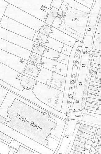
As you can tell from all my topics lately, I've been doing a lot of research into Dartmouth Road. I believe I've seen every old building down this road, pictured in old photographs, except the houses that stood between the swimming baths and Derby Hill (not seen the old villas up here either).
The top of Dartmouth Road curving round to Kirkdale was once known as the High Street before Walter Cobb brought it closer towards Sydenham Road. It seems this part of Kirkdale I'm referring to might also have been mistaken for an extention of Dartmouth Road; for example, I've seen the photo below captioned as being in Dartmouth Road.
I don't know much about those buildings in the background, and not even Steve knows what the tall building is on the right.
I've found some more photos lately, dated around 1912, and need help finding them on the map; I'm wondering if they could possibly match any of the unseen buildings outlined above?
133 + 135 High Street, Sydenham / Dartmouth Road (east elevation)
133 + 135 High Street, Sydenham / Dartmouth Road (west elevation)
135 High Street, Sydenham / Dartmouth Road
137 High Street, Sydenham / Dartmouth Road (west elevation)
137 + 139 High Street, Sydenham / Dartmouth Road (east elevation)
137 + 139 High Street, Sydenham / Dartmouth Road (west elevation)
No information....
Dartmouth Road / Old Sydenham High Street
-
- Posts: 606
- Joined: 4 Oct 2004 05:07
- Location: Upper Sydenham
Falkor, 133-139 High Street were two pairs of villas at the other end of Dartmouth Road. They were built in the late 1850s and demolished in about 1919 to make way for Sydenham School (their site is covered by the school building). They were part of a group of villas that extended to Round Hill of which two still survive, incorporated into Courtside.
The stuccoed pair of villas in the last picture also survive, opposite the swimming pools (I think they are 107-109 Dartmouth Road). They were built in the early 1840s (they both appear on the 1843 Tithe map).
By the way, I'm taking a historical walk for the Forest Hill Society this Sunday (25 Feb, meet 2pm at Christ Church, finish 4pm at the Capitol). You, or anyone else, will be more than welcome to join me.
Thanks for the information and invititation, Steve! I know I'll be there, and I promise to behave myself. I have this habit of asking too many questions, but I'll make sure I shut up on the day, so the walk is able to progress and I don't slow you down. I don't know much about London Road, Hornimans and Honor Oak Road, and I'm just starting to learn about Perry, so it should be interesting. I saw all those wonderful photos you put up and wondered what they were at first, but now I know. Some of those are intrigueing, especially the atmospheric railway engine house!? Glad to see a high quality version of the possible Croydon Canal remnant you once showed me, as well as the Forest Hill station building on Perry Vale side, which I was unable to find in the studies centre. So quite a nice batch of rare photos there, and I look forward to the walkabout.
-
- Posts: 51
- Joined: 10 Mar 2008 20:16
- Location: Anerley
Re: Dartmouth Road / Old Sydenham High Street
Can anyone help me with pictures (or information) relating to the Shop or Works which was at 57a High Street Sydenham, recorded as Business Premises on the 1920 Electoral Roll (page 34) and 1925 Electoral Roll (page 30)?
I've searched through all the many pictures on this forum and can't find anything of that particular stretch. It was up the hill on the street covered in this thread, and not on Sydenham Road (Kirkdale to Bell Green) which according to Wikipedia is known as Sydenham High Street "by locals."
In 1920-1925, it was owned by Sidney George Kernick and his wife Julia Emma Kernick née Dellow (a distant cousin of mine). His place of abode was 302, Upland Road, Dulwich, Southwalk. He was a joiner by trade, and in the 1911 Census was a Joinery Manager, so I am assuming it was a Joinery.
In the 1911 Census it was a hair dressers and an Arthur James Stevens occupied it. There was a bootmaker at 59 and a family occupying 57.
The Kernicks had moved to Twickenham sometime before 1930.
If that street was all shops, the 1920 and 1925 Electoral Rolls only show 57a as a Business Premise. Had the decline of that area as a commerical concern taken place already?
From this thread it would appear that was the case:
http://sydenham.org.uk/forum/viewtopic. ... 120&p=7134
Re: Dartmouth Road / Old Sydenham High Street
The houses in the back ground look like the back of 30/32/34 halifax street