Kelvin Grove
Kelvin Grove
I love all the local history info on Wells Park and particularly Mount Ash Road, since I used to live there.
Does anyone know about the history of Kelvin Grove? Why was it named that, famous people etc, when the big houses were built etc. I think the houses were built in 1860 is and originally had names (eg xx Villa).
Any old pictures anywhere?
Does anyone know about the history of Kelvin Grove? Why was it named that, famous people etc, when the big houses were built etc. I think the houses were built in 1860 is and originally had names (eg xx Villa).
Any old pictures anywhere?
Steve Grindlay already suggested a possible reason why it was named Kelvin Grove (see the Old Wells Park topic), but said it would be impossible to prove.
I've not seen any old photos of the road, but with the same buildings, I doubt it would have looked much different. What leaf and myself is interested to know about is the old Kelvin Grove School and the 1980s fire that destroyed it. Also, many years ago, there used to be a building in place of the Nursery at the end--I think it might have been a pub.
I've not seen any old photos of the road, but with the same buildings, I doubt it would have looked much different. What leaf and myself is interested to know about is the old Kelvin Grove School and the 1980s fire that destroyed it. Also, many years ago, there used to be a building in place of the Nursery at the end--I think it might have been a pub.
There's a photo in the book "Sydenham and Forest Hill" looking up Kirkdale from the junction with Dartmouth Road. You can just make out what I think looks like part of the pub sticking out from Kelvin Grove, but it's hard to say at this angle. Part of the caption reads "The beerhouse at its far corner was the Kelvin Arms, which had been established in the 1870s. It became an off-license in the 1930s, and was destroyed by bombing during the war. The Kelvin Grove Nursery School now stands on its site."
Would be nice to see a proper photo of the pub... maybe Steve Grindlay has got one?
Would be nice to see a proper photo of the pub... maybe Steve Grindlay has got one?
-
Steve Grindlay
- Posts: 606
- Joined: 4 Oct 2004 05:07
- Location: Upper Sydenham
Yes, I have since found the info Steve put into the Wells Park thread about the origins of Kelvin Grove's name (thank you), which was:
"One source (Joan Read's Lewisham Street Names, 1990) suggests it was named after Lord Kelvin in about 1850. This cannot be so, as William Thomson was not created Baron Kelvin until 1892 and the street was certainly known as Kelvin Grove by 1858. Lord Kelvin took his title from Kelvin Grove (or Kelvingrove) in Glasgow. It is, I suppose, possible that the developer of Kelvin Grove in the 1850s simply named the street after his home town, but that will be difficult to prove. Still, at over 150 years old, it is amongst the oldest surviving street names in Upper Sydenham.".
As far as the houses go, they're on the 1868 OS map Steve posted, but not Stanford's 1862 one, so at least we've dated their likely build date.
Kelvin Grove Primary School dates back to 1873 but has obviously been added to since then.
-
Steve Grindlay
- Posts: 606
- Joined: 4 Oct 2004 05:07
- Location: Upper Sydenham
That's not quite right, BingBong. A street directory of 1858 lists three households in Kelvin Grove, and the 1861 census has five. As the occupations are fairly humble (plumber, railwayman, gardener) I imagine this was the small terrace that filled the gap between the small infants' school and the first surviving house (it may even have extended almost to Kirkdale). Part of this terrace does seem to appear on the Stanford's map. I agree that the surviving detached villas date from the mid-1860s.BingBong wrote:...As far as the houses go, they're on the 1868 OS map Steve posted, but not Stanford's 1862 one, so at least we've dated their likely build date.
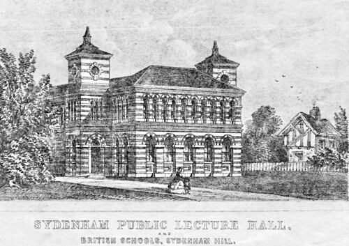
This picture may be of interest. It shows the original design for the Kirkdale Institute and if not actually drawn by Joseph Paxton in about 1860 was certainly based on his designs:

I am at a loss to explain the Tudor cottage that appears in Kelvin Grove. I can ony put it down to artistic licence on the part of the architect.
I've written an article on the Kirkdale Institute [here]
-
Steve Grindlay
- Posts: 606
- Joined: 4 Oct 2004 05:07
- Location: Upper Sydenham
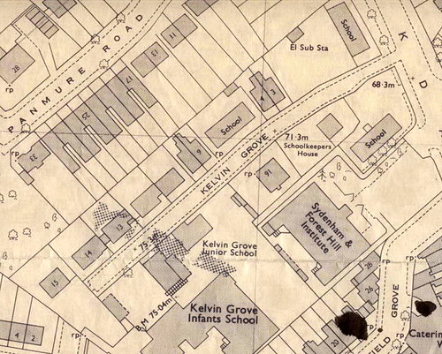
It was a large scale (1:1250) Ordnance Survey map, revised in 1975. Here's the Kelvin Grove part of it:In the Fransfield Grove thread BingBong wrote:That's an interesting map you've shown there Steve. Where's it from? What's the approx date? I'd like to see more of the bit top left, following on from my Kelvin Grove enquiries.

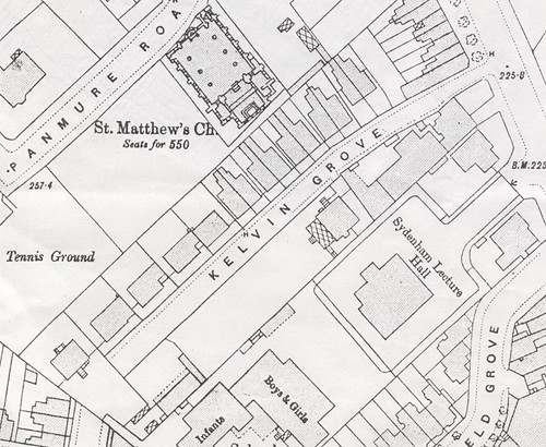
For comparison, here's the same section from the 1895 OS map:

What treats - where on earth did you find the pictures?
I don't know about the first picture, other than it looks like one of the houses on Kirkdale, up the hill from and on the same side as the nursery as it is today.
I don't know which houses are in pic 2, but
Pic 3 shows, from right to left, part of number 11, then 12 and 13 Kelvin Grove.
Pic 4 shows (from right to left), the semis at numbers 9&10, then 11, 12, 13 and part of 14 Kelvin Grove.
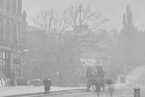
Pic 5 of Kelvin Cottage is interesting - with the name, it must have been one of the buildings towards the Kirkdale end, presumably still in Kelvin Grove and where either the nursery is today, or the building opposite which is currently being made into a children's centre so the government can nanny local parents even more.
Pix 6, 7, 8, and 9 are also a mystery but if you unearthed them in the same batch, they must be local to K Grove (the architecture would suggest so at least).
It's tricky to pin down the Kelvin Grove houses with the 1871 census, as they weren't numbered in those days - there was an Ettrich House, Avon Villa, Bruce Villa etc.
-
Steve Grindlay
- Posts: 606
- Joined: 4 Oct 2004 05:07
- Location: Upper Sydenham
Pictures 1-4 are of the surviving houses in Kelvin Grove. The first picture is no.15 then possibly 14 and 13 (difficult to be sure as they are so similar). The 4th picture shows 9-10 on the left. All these houses survive.
The remaining pictures are of a group of buildings on the opposite side of the road, from the Kirkdale junction to the caretakers house (now being converted). You can see them in the 1895 map above. Kelvin Cottage actually fronted onto Kirkdale.
You're right, BingBong, it is difficult to pin down the houses although I'm fairly sure, but by no means certain, that Ettrich House, Avon Villa and Bruce Villa were the present nos.12-14, in that order.
-
Genealogist
- Posts: 2
- Joined: 13 Jul 2008 22:53
- Location: USA
Kelvin Grove Houses
The pictures above look very similar to the Kelvin Grove Postcard I have from 1905. Can anyone identify this house or tell me if it is still standing?

My grandfather is the boy on the left.
The Genealogist.

My grandfather is the boy on the left.
The Genealogist.
-
catscratch
- Posts: 83
- Joined: 13 Jul 2008 12:44
- Location: se20
I went to school in Kelvin Grove just after the war.
These ruined houses and makeshift garages are typical of what one could see at that time; these would mostly be the damage caused by the V2 on Panmure Road.
No 15 Panmure built on the site of the church has or had, remains of foundations in its garden,used a a step down
I remember the school at the corner of Kelvin /Kirkdale being built, it was a prefab building, since replaced.
The teacher built a rose Garden on the corner aspect, using bomb rubble bricks as terracing.
One of my classrooms was the prefab building further up, which backs onto the church site.
I an sure Bruce Villas still remains, look for the name either over the door or on a gate post.
Kelvin Grove school was regarded as a bit rough, especially as one Lady Lewisham once visited it for some reason, and complained that the kids spat on her car[while she was in it!]
But not as rough as the Kilmory annexe,nearby.
Incidentally,reading the post about the V2 on Panmure road, I think it fell on the road or front gardens of what is now 10-18, if you look at them the front gardens are quite elevated, probably because all the rubble was bulldozed into the crater, as normal.
The tennis courts were long gone by the 1940's; that area was just waste ground till the late 1970's.
The house next to it, not the bungalow, was inhabited by a cypriot family, with a witch of an old woman. granny I think, who spoke no english but used to terrify us kids by chasing us away from her gate with a coal axe.
Somehow Sydenham/Kirkdale remains in my memory as a happy place to be a kid, probably because of that very dereliction shown in these photos.
I can remember the milk being delivered in this area by horse and cart; On Sundays a man would push a handcart about, selling shrimps and winkles; standard Sunday tea.
At 5 yrs old I would walk home for lunch, no need to be met by a parent, those few who were were regarded as a bit sissy. No one had a car either.
-
Steve Grindlay
- Posts: 606
- Joined: 4 Oct 2004 05:07
- Location: Upper Sydenham
Re: Kelvin Grove Houses
It is certainly not still standing in Kelvin Grove, and I have to say that it does not look very much like the surviving houses there. Do you know for certain that it shows a house in Kelvin Grove, and do you have any more information, such as the house number or the family name?Genealogist wrote:The pictures above look very similar to the Kelvin Grove Postcard I have from 1905. Can anyone identify this house or tell me if it is still standing?
-
Genealogist
- Posts: 2
- Joined: 13 Jul 2008 22:53
- Location: USA
Kelvin Grove Houses
The Postcard is stamped Smith & Garland Photographers, Larkbere Rd, Sydenham. I guess I should have given them credit in my first post.The Kelvin Grove Postcard I have from 1905
Handwritten on the card is 'The Bungalow", Kelvin Grove, Upper Sydenham.
The family name would have been GREENHILL. They were living elsewhere in the 1901 census and emigrated to Canada in 1909 so it is a very small window for them to be in Kelvin Grove.
The Genealogist


