Pictures of the Croydon Canal
I'm hoping to build up a collection of illustrations and photos pertaining to the Croydon Canal--along all stretches, so will be adding to this topic in due course. If anyone else has any images they can kindly contribute, including any higher res/colour upgrades, then please do so. I can then edit them into this opening post.
Will's excellent superimposition of the Croydon Canal route on Google Maps...
Junction of Grand Surrey Canal and Croydon Canal
Five Bell Lane, New Cross
"'View from the Locks above Deptford' engraved in 1851. The fence by the head of the lock was the boundary fence between the two counties, and therefore the modern view is almost at the head of Lock No.9. Modern scenes like the one above do little justice trying to envisage how the canal looked."
Deptford/New Cross/Telegrath Hill? More info needed...
Lock House near Brockley Station area.
Apparently, one of the original lockkeeper's cottages at Brockley Way Bridge, photographed after the canal closed and was drained, probably in the 1960s.
Now thought to be of railway origin
Brockley Way Bridge
Looking southwest from Brockley towards Forest Hill with One Tree Hill in the background. More info here...
Looking northeast, "the picture shows the bottom of the staircase lock at Honor Oak, identifable because it has a swing bridge across the chamber. The small lane crossing the lock chamber, is Honor Oak Park's precessdor. Despite being a 'pair' of locks, it was numbered as one lock - 26 contrary to canal practice - the Croydon canal had a total of 29 locks when these and the two Norbury locks are included." (*UPGRADE COMING SOON)
The view is taken from Honor Oak Park in the southwest direction, showing some of the Honor Oak Road houses in the background. In the foreground is the last 2 locks of the 29 that started at New Cross to help the bargees ascend the terrain; most locks--#11 to #29--were between Brockley Station and Honor Oak Park (the predecessor to this road can be seen in the engraving crossing horizontally over the swing bridge coupled with the top of the staircase lock). It was a simple, but slow, journey from here to Croydon. Straight ahead was one of the most attractive parts of the canal set inside Honor Oak Wood. The canal emerged out of the woods when winding eastwards across the line of the future Devonshire road, before winding back round to the south towards Davids Road with woodland still on the eastern bank as far as Woodcombe Crescent.
Top of the staircase lock at Honor Oak Park, looking southwest, with the lockkeeper's cottage in the background. (*IMAGE IN NEED OF UPGRADE)
Somewhere in Sydenham (could be from the pool at the north end of Davids Road. (*IMAGE IN NEED OF UPGRADE)
Remains of the canal? Photo taken from the pathway at the side of the railway line--said to be a descendant of the canal towpath.
Sydenham Common, including the reservoir. (*IMAGE IN NEED OF UPGRADE)
Surviving stretch of the canal seen in Dacres Wood Nature Reserve.
Looking towards The Greyhound and Sydenham Bridge. "This was drawn in 1818 and shows the Croydon Canal at the bottom left corner. The viewpoint is from about the present station footbridge over the railway line, and the cows are approximately in the present pub car-park."
Sydenham Bridge looking south.
Sydenham Bridge looking north.
Sydenham Bridge looking north. (*IMAGE IN NEED OF UPGRADE)
Two views of Penge Bridge. (*IMAGES IN NEED OF UPGRADE)
Penge Bridge.
Anerley. (*IMAGE IN NEED OF UPGRADE)
Anerley. (*IMAGES IN NEED OF UPGRADE)
A stretch of the Croydon Canal being used for recreational purposes as part of Anerley Gardens. (*IMAGE IN NEED OF UPGRADE)
Canal remnant after closure near Anerley Bridge.
Early view of the old canal remains in Betts Park, Anerley. (*IMAGE IN NEED OF UPGRADE)
Early view of the old canal remains in Betts Park, Anerley. (c1900)
Early view of the old canal remains in Betts Park, Anerley. (1905)
Betts Park today showing surviving stretch of old canal.
Unknown stretch of the canal (*IMAGE IN NEED OF UPGRADE)
The surviving South Norwood Reservoir.
South Norwood looking towards Anerley. (*IMAGE IN NEED OF UPGRADE)
THIRD surviving section of the canal--"An unofficial access from Sunnybank accesses remains of the towpath bank itself (left) in which view we are looking along the former route southwards in the direction of Croydon. To the side (right) a substantial profile of the canal can be seen, in use as gardens, but some uncertainty about ownership appears to have left them rather open to access by members of the public. This stretch of canal was still watered in 1862, and according to the authors of 'South Norwood and the Croydon Canal,' the remnants of the canal finally succumbed to further house building by the end of the 19th Century."
Selhurst impression.
Will's excellent superimposition of the Croydon Canal route on Google Maps...
Junction of Grand Surrey Canal and Croydon Canal
Five Bell Lane, New Cross
"'View from the Locks above Deptford' engraved in 1851. The fence by the head of the lock was the boundary fence between the two counties, and therefore the modern view is almost at the head of Lock No.9. Modern scenes like the one above do little justice trying to envisage how the canal looked."
Deptford/New Cross/Telegrath Hill? More info needed...
Lock House near Brockley Station area.
Apparently, one of the original lockkeeper's cottages at Brockley Way Bridge, photographed after the canal closed and was drained, probably in the 1960s.
Now thought to be of railway origin
Brockley Way Bridge
Looking southwest from Brockley towards Forest Hill with One Tree Hill in the background. More info here...
Looking northeast, "the picture shows the bottom of the staircase lock at Honor Oak, identifable because it has a swing bridge across the chamber. The small lane crossing the lock chamber, is Honor Oak Park's precessdor. Despite being a 'pair' of locks, it was numbered as one lock - 26 contrary to canal practice - the Croydon canal had a total of 29 locks when these and the two Norbury locks are included." (*UPGRADE COMING SOON)
The view is taken from Honor Oak Park in the southwest direction, showing some of the Honor Oak Road houses in the background. In the foreground is the last 2 locks of the 29 that started at New Cross to help the bargees ascend the terrain; most locks--#11 to #29--were between Brockley Station and Honor Oak Park (the predecessor to this road can be seen in the engraving crossing horizontally over the swing bridge coupled with the top of the staircase lock). It was a simple, but slow, journey from here to Croydon. Straight ahead was one of the most attractive parts of the canal set inside Honor Oak Wood. The canal emerged out of the woods when winding eastwards across the line of the future Devonshire road, before winding back round to the south towards Davids Road with woodland still on the eastern bank as far as Woodcombe Crescent.
Top of the staircase lock at Honor Oak Park, looking southwest, with the lockkeeper's cottage in the background. (*IMAGE IN NEED OF UPGRADE)
Somewhere in Sydenham (could be from the pool at the north end of Davids Road. (*IMAGE IN NEED OF UPGRADE)
Remains of the canal? Photo taken from the pathway at the side of the railway line--said to be a descendant of the canal towpath.
Sydenham Common, including the reservoir. (*IMAGE IN NEED OF UPGRADE)
Surviving stretch of the canal seen in Dacres Wood Nature Reserve.
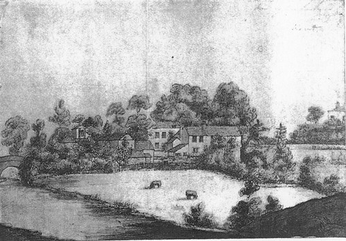
Looking towards The Greyhound and Sydenham Bridge. "This was drawn in 1818 and shows the Croydon Canal at the bottom left corner. The viewpoint is from about the present station footbridge over the railway line, and the cows are approximately in the present pub car-park."
Sydenham Bridge looking south.
Sydenham Bridge looking north.
Sydenham Bridge looking north. (*IMAGE IN NEED OF UPGRADE)
Two views of Penge Bridge. (*IMAGES IN NEED OF UPGRADE)
Penge Bridge.
Anerley. (*IMAGE IN NEED OF UPGRADE)
Anerley. (*IMAGES IN NEED OF UPGRADE)
A stretch of the Croydon Canal being used for recreational purposes as part of Anerley Gardens. (*IMAGE IN NEED OF UPGRADE)
Canal remnant after closure near Anerley Bridge.
Early view of the old canal remains in Betts Park, Anerley. (*IMAGE IN NEED OF UPGRADE)
Early view of the old canal remains in Betts Park, Anerley. (c1900)
Early view of the old canal remains in Betts Park, Anerley. (1905)
Betts Park today showing surviving stretch of old canal.
Unknown stretch of the canal (*IMAGE IN NEED OF UPGRADE)
The surviving South Norwood Reservoir.
South Norwood looking towards Anerley. (*IMAGE IN NEED OF UPGRADE)
THIRD surviving section of the canal--"An unofficial access from Sunnybank accesses remains of the towpath bank itself (left) in which view we are looking along the former route southwards in the direction of Croydon. To the side (right) a substantial profile of the canal can be seen, in use as gardens, but some uncertainty about ownership appears to have left them rather open to access by members of the public. This stretch of canal was still watered in 1862, and according to the authors of 'South Norwood and the Croydon Canal,' the remnants of the canal finally succumbed to further house building by the end of the 19th Century."
Selhurst impression.
Last edited by Falkor on 25 Mar 2008 22:45, edited 9 times in total.
-
- Posts: 352
- Joined: 14 Jan 2008 23:45
- Location: moorlinch
This is brilliant stuff, Falkor.
I was looking at the picture of what is supposed to be the top lock.
It only has 2 sets of gates, instead of 3, and the swing bridge is straight over..... if there was a lockkeepers cottage at brockley road, this is more likely to be where the photo was taken from.
same with the other drawing...the cottage is on the north side.
the painting is almost certainly the honor oak lock.
just a few thoughts as it all starts to take shape.
there are some fantastic images here
thanks.
I've got some major upgrades--mainly thanks to Ian of Beckenham History!!!! Maybe I cannot update everything tonight, but even so, I'll try... I got 2 new books for Will! Oh yeah, and next week we finally get an upgrade (scanned) of my most wanted:
Until then... cheers!
This original has disappeared from the face of the earth:
If anyone knows about it then speak up!
Until then... cheers!
This original has disappeared from the face of the earth:
If anyone knows about it then speak up!
-
- Posts: 352
- Joined: 14 Jan 2008 23:45
- Location: moorlinch
This is good news.
Well done, Falkor!.
as for the 3d map......I've been measuring the locks into place, and I'm about to start adding wharves etc...
(check here for latest ;
http://maps.google.com/maps/ms?hl=en&ie ... &z=15&om=0
Well done, Falkor!.
as for the 3d map......I've been measuring the locks into place, and I'm about to start adding wharves etc...
(check here for latest ;
http://maps.google.com/maps/ms?hl=en&ie ... &z=15&om=0
-
- Posts: 606
- Joined: 4 Oct 2004 05:07
- Location: Upper Sydenham
Falkor, the drawing titled "Near Penge Common", from Ken White's book, has [GLRO] under the caption. That was the Greater London Records Office. When Thatcher abolished the GLC the GLRO became the London Metropolitan Archive and that, I would expect, is where the original is housed. I know Ken White well; he pops round every few weeks for a chat. Next time I see him I will ask about the drawing.
Thanks Steve! I not tried the LMA yet... BTW, have you got a good scan of the Sydenham Common painting by any chance that you could share with us please? It shows the Sydenham Reservoir... All the copies I got are crap...
I'll get these upgrades sorted today. I'm becoming quite fascinated by the Norwood Loop section of the Croydon Canal, and the fact that there are no images of the canal at the Croydon end. One book I got for Will is about the Norwood Loop, where be the 3rd suviving stretch. The other book is about an excavation in Davidson Road--looks very interesting! Shame there was no report about the excavations at the back of the Dartmouth Arms. Steve, did you take anymore pictures of those possible remains from different angles? I suppose you got it at the perfect angle already. I just feel that more should have been done at the time. Sydenham needs it's own archaeological society.
Hey Will, fancy joining me for an unofficial dig at Honor Oak, in search of a lock chamber? Nothing will get done in our lifetime, so we might as well have a go now, even if we accidentally destroy some roman remains at the same time. All we need is to employ a gardener for the day to clear up after us and make sure everything is landscaped over again. I can take the pictures and do the write up. You just need to bring a spade... so how about it then? This kind of thing is best left to amateurs like us. If we find a Roman villa then we only have to call up the archaeological rescue team, and they will gladly take over from us.
-
- Posts: 352
- Joined: 14 Jan 2008 23:45
- Location: moorlinch
aah!
Now you're talking!
If you reckon we could get away with it, I'm well up for such a venture.
(If you set it it up, i'll head up to london...)
I'm pretty sure we could locate all the locks in situ, but only locks 23 - 24 look diggable, (but 24 seems to be in the cemetary.)...part of lock 22 may turn out to be outside the tennis court too, soo that may be worth a look.
locks 20 and 21 are either within the crematorium or so deep in infill we'd never get there.
I'll try to work out how deep we may be looking...should be possible.
anyway...how exciting!
(we'll have to have a talk about the digging though, eh )
-
- Posts: 352
- Joined: 14 Jan 2008 23:45
- Location: moorlinch
Whose thinking of stopping us!? They would seem to be tired of living...If you reckon we could get away with it, I'm well up for such a venture.
So that's settled then. I'll be in contact once everything is arranged. Where do you have to travel from?
When we are done, we can set up our own archaeological society together, as joint partners.
-
- Posts: 352
- Joined: 14 Jan 2008 23:45
- Location: moorlinch
i'm in somerset...but my mum lives in Forest Hill so thats not a problem...
(my digging abilities may be diminished due to a cracked rib etc, but if we can sort it for late february or so...that'd be wonderful.)
....gives us time to get the measurements as close as possible too.
email me when you have any more info, eh?
(my digging abilities may be diminished due to a cracked rib etc, but if we can sort it for late february or so...that'd be wonderful.)
....gives us time to get the measurements as close as possible too.
email me when you have any more info, eh?
-
- Posts: 352
- Joined: 14 Jan 2008 23:45
- Location: moorlinch
Many thanks for those new books Falkor.
should keep me busy for a bit.
(I hope this image works...just a slight update to the original)
I hope this works..see what you think)
should keep me busy for a bit.
(I hope this image works...just a slight update to the original)
I hope this works..see what you think)
Last edited by will greenwood on 10 Feb 2008 16:13, edited 1 time in total.
-
- Posts: 352
- Joined: 14 Jan 2008 23:45
- Location: moorlinch
-
- Posts: 352
- Joined: 14 Jan 2008 23:45
- Location: moorlinch
Hi
I've just updated the Google Earth map with some of the images from this post, along with placemarks etc...
..and I reckon the Honor Oak locks are much more accurate this time
(I'm sure there'll be some debate about my choice of siting, but thats part of the fun, eh?)
http://maps.google.com/maps/ms?hl=en&ie ... &z=13&om=0
-
- Posts: 606
- Joined: 4 Oct 2004 05:07
- Location: Upper Sydenham
This is becoming a really fascinating thread.
What convinces me that this site is connected with the canal is the line of carved sandstone blocks, very similar to those at New Cross Gate that have also been connected with the canal.
I did take a couple of others, that I've uploaded <here>. These pictures must have been taken ten years ago. Before the workmen moved in there had been a wall, with buttresses supporting it (one of which is shown). The wall was removed and the bank cut back; that is what the pile of clay is. Amongst the debris was a lot of material relating to the pub; beer bottles, clay pipes and so on. I picked up a few bits, intending to go back, but a couple of days later the whole site had been enclosed.Falkor wrote:Steve, did you take anymore pictures of those possible remains from different angles? I suppose you got it at the perfect angle already. I just feel that more should have been done at the time. Sydenham needs it's own archaeological society.
What convinces me that this site is connected with the canal is the line of carved sandstone blocks, very similar to those at New Cross Gate that have also been connected with the canal.
I have no idea where the original painting is. The only copy I know of is the one I imagine you've seen in Croydon Local Studies (I know that both Joan Alcock and John Coulter used that copy). When I asked the staff where the copy came from, none of them knew.Falkor wrote:...have you got a good scan of the Sydenham Common painting by any chance that you could share with us please? It shows the Sydenham Reservoir.
-
- Posts: 3
- Joined: 28 Jan 2008 10:05
- Location: Rutland
Swing bridges on the Croydon Canal
Hello Falkor
I am composing a history of movable bridges in the British Isles - my website is www.movablebridges.org.uk.
I have just found your posting of images of the Croydon Canal and in particular the old illustration of a swing bridge, beneath which you state that '30 such bridges were recorded'.
I had not previously come across this canal in relation to my research. I find from my copy of Priestley's 'Navigable Rivers and Canals' that the Croydon Canal opened in 1809, with John Rennie and Ralph Dodd as engineers, although I now know that it closed again in 1830.
I only have access to OS maps from 1882 for this part of the country at present, by which time the railway had been built over most of the route of the old canal.
Would you mind telling me what your source was that recorded 30 swing bridges, so that I can seek it out and try and establish where the bridges were along the 9 mile route? I can then add them to my database.
Hope you can help
Stewart Marchant
-
- Posts: 352
- Joined: 14 Jan 2008 23:45
- Location: moorlinch
I was adding the swing bridges to the map, prompted by the last post, when I found this reference to a cottage at the site of the black and white photo of the possible lock keepers cottage.
at least this seems to suggest it was a canal property.
To quote from p.116 of the Ken White book;
"...Another swing bridge is 570 yards from this one (Shardeloes Rd), and 34 yards before it on the east of the towpath a small cottage is situated. This is for a canal employee, reputedly a lock keeper, but I have no description of his duties. The cottage survived until 1946, and may be represented by a small piece of wall with english bond opposite Millmark Grove, which is the site. Anewspaper reproduction exists of a picture from the north west......."
so, looking the other way towards crofton park, then?