Prospect Place, Wells Road
Prospect Place, Wells Road
Thanks to Illuminance, I was checking out the 1862 Standford map, and noticed an even older wave of buildings along Wells Park Road than what is evident from the Sydenham history books and later 1894/1914 maps.
Before Prospect Close was built as part of the Wells Park housing estate, roughly in it's place was Prospect Road (page 73 in Forest Hill and Sydenham). However, I never realised that before Prospect Road was built, there was a terrace of buildings on the other side of the road called Prospect Place!
Looking at the map, Prospect Place covered the entire area from East of where the Duke now stands, going right across to the opposite corner of where Dallas Road was to be laid out. If Dallas Road existed in 1862, Prospect Place would have blocked off the entrance.
Does anyone know, or please can you find out, if Prospect Place was houses or shops? Any online directories available from this period? Also, could there be any illustrations/photos of Prospect Place or the Beehive pub that later got replaced by the Duke?
Any help would be much appreciated!
-
Steve Grindlay
- Posts: 606
- Joined: 4 Oct 2004 05:07
- Location: Upper Sydenham
Falkor I've uploaded extracts from both the 1862 and 1878 Stanford's maps - http://tinyurl.com/noel5 - for comparison. In the 1861 census there are entries for 1-6 Prospect Place, and they are occupied by a gardener, carpenter, bricklayer, railway excavator etc. Clearly not shops, but I suspect a terrace of rather humble cottages. I believe they are the block of buildings under the"ros" of Prospect, in both maps. The cottages, although not named, appear in the 1843 Tithe Map
Steve
Steve
Nice one! I never realised there was a 1878 Stanford map to fill in even more of the gaps, including parts of the new roads being laid out. The Standford maps appear to show different details to the OS maps. It appears that the eastern side of Prospect Place was demolished to make way for the entrance to Dallas Road, which is quite ironic. I wonder if this Dallas Cottage had anything to do with the left-overs...Falkor I've uploaded extracts from both the 1862 and 1878 Stanford's maps - http://tinyurl.com/noel5 - for comparison.


Cheers, Steve.. thanks for checking! Considering the next 2 waves of buildings on that stretch were to be shops, and the fact that they are right next to a pub (Beehive first then Duke), I thought there was a possibility of Propsect Place being shops, but it doesn't appear so; oh well.In the 1861 census there are entries for 1-6 Prospect Place, and they are occupied by a gardener, carpenter, bricklayer, railway excavator etc. Clearly not shops, but I suspect a terrace of rather humble cottages. I believe they are the block of buildings under the"ros" of Prospect, in both maps.
There's an 1843 map for this part of upper sydenham!? I assumed, going this far back, the only reliable map showing existing houses would be the 1849 Sewage map; would love to see this even earlier Tithe map you refer to... I know I'm pushing my luck here, but any chance of uploading an extract from this, too, perhaps with a slightly larger radius showing the top of Springfield? Would be interesting to see how accurate this is...The cottages, although not named, appear in the 1843 Tithe Map
I think I'll scan in my photo of Rosamond Street in super duper quality...
-
Steve Grindlay
- Posts: 606
- Joined: 4 Oct 2004 05:07
- Location: Upper Sydenham
I've put part of the tithe map with the other Wells Park maps. You can't see much detail as it's a poor quality photocopy; you'd have to go to local studies to see the original. Each plot of land on the map is numbered, and local studies has an index showing the owner of each plot, and the tenant and what the land was used for. The tithe maps were accurate in the sense that they were concerned with who owned what property and so boundaries and buildings were quite carefully recorded.
I'll upload the Stanford 1878 map showing more of Wells Park Road
By the way, I don't recognise the cottage - where was it?
I'll upload the Stanford 1878 map showing more of Wells Park Road
By the way, I don't recognise the cottage - where was it?
-
Scott George
- Posts: 2
- Joined: 4 Apr 2009 08:47
- Location: Dublin & Shanghai
Prospect Place
Very intersted to see this comment about Prospect Place. Before I could only find ref to Prospect Road, but I knew 'Place' existed in 1950 as it was the home to my grandparents. Their house was (I believe) 52 Prospect Place. It wasnt a large house, 3 smallish bedrooms, a front sitting room downstairs with a smaller room behind and then a kitchen beyond. They did have a bathroom upstairs as well as an old outside privvy at the rear. There was no front garden, just a small railing along the frontage about half a metre out from the entrance. The house was terraced and looked rather plain, typical frotage with two windows upstairs, with one downstairs next to front door.
At the end of Prospect Place was a large wall, making it a small cul-de-sac.
At the time my parents were living in Wells Park Road, No 112. This house was demolished in 1955, as some in the terrace had received bomb damage. One house had a rather exciting experience during the war when a German pilot was captured after parachuting into a tree at the rear of the house...He was on a raid over Crystal Palace at the time.
I remember the Methodist Mission just opposite our house, although I'm sure this is no longer there.
It is great to see mention of these places...Thank you.
-
Steve Grindlay
- Posts: 606
- Joined: 4 Oct 2004 05:07
- Location: Upper Sydenham
Scott George, you have me completely baffled by your mention of Prospect Place in the 1950s. Could you tell me a little more. For example, where was it in relation to, say, Rowland Grove or Dallas Road and, if you wish, what was the name of the family who lived at number 52, and how long did they live there?
Several people have told me about the German pilot parachuting into the area; it clearly caused a great deal of excitement.
Several people have told me about the German pilot parachuting into the area; it clearly caused a great deal of excitement.
-
Scott George
- Posts: 2
- Joined: 4 Apr 2009 08:47
- Location: Dublin & Shanghai
Prospect Place was on the opposite side of the road from Dallas Road. It was th former name of Prospect Close. At the time I was there (abt 1948-1953) it was definitely a cul-de-sac. I think on the corner f Wells Park Road and Prospect Place was a small sweet shop...
The people who lived there, my grandparents, were called GEORGE (Frederick)
Hope this helps.
The people who lived there, my grandparents, were called GEORGE (Frederick)
Hope this helps.
-
Steve Grindlay
- Posts: 606
- Joined: 4 Oct 2004 05:07
- Location: Upper Sydenham
Are you sure it wasn't Prospect Road? According to Kelly's Directories Frederick George was living at 52 Prospect Road during the 1920s and 1930s (I don't have access to post-war records from home). This map shows Prospect Road which was, indeed, a dead-end:

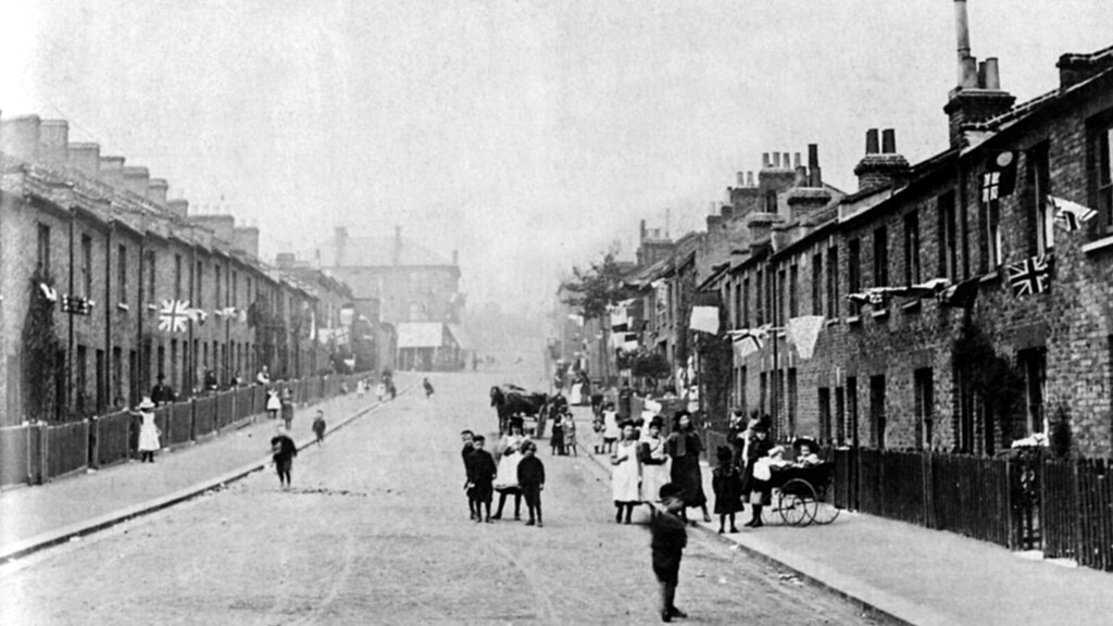
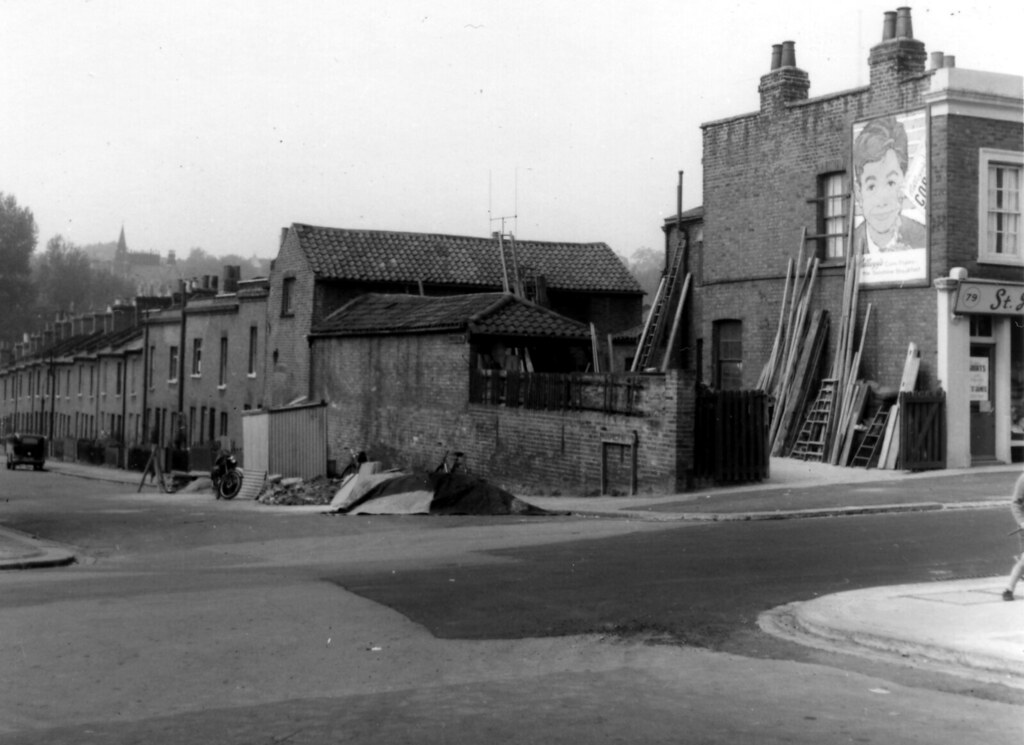
Here are a couple of pictures of Prospect Road:

This is looking towards Wells Park Road.

This is from the corner of Dallas Road. Incidentally, the shop on the right (79 Wells Park Road) was at one time a confectioners.

Here are a couple of pictures of Prospect Road:

This is looking towards Wells Park Road.

This is from the corner of Dallas Road. Incidentally, the shop on the right (79 Wells Park Road) was at one time a confectioners.
-
Steve Grindlay
- Posts: 606
- Joined: 4 Oct 2004 05:07
- Location: Upper Sydenham
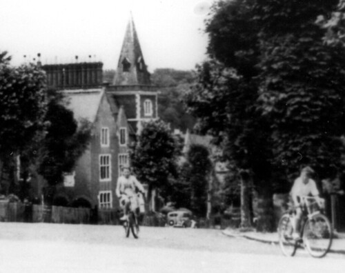
It's actually not a church, Ulysses, but the tower of a house on Longton Grove. This shows the house looking down Longton Grove from Westwood Hill:

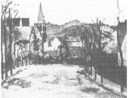
This view has the distinction of having been painted by Camille Pissarro. This is a poor copy; the original, apparently, has not been seen since 1928:


This view has the distinction of having been painted by Camille Pissarro. This is a poor copy; the original, apparently, has not been seen since 1928:

Oh. I think the elevation tricked me. I presumed (wrongly) that the photograph was taken looking toward Sydenham Hill due to the high nature of the spire. When in actual fact we are looking 'down' Dallas Road and across toward the large bulding.
I needed to spin myself 180degrees in my mind?
Thanks again. The chimney pots in the painting do indeed 'stack' up with the photograph...
I needed to spin myself 180degrees in my mind?
Thanks again. The chimney pots in the painting do indeed 'stack' up with the photograph...
-
samantha joslin
- Posts: 1
- Joined: 14 Jul 2010 18:44
- Location: Kent
Re: Prospect Place, Wells Road
New to this forum, ancestors lived in Prospect Road, I myself went to St Philips CofE. I have photos of the street in the thirties and forties, are these of any interest to anyone?
Understand from relations that my ancestors ran some of the shops at the top of Prospect Road. How would I get hold of further prints of some of the photos featured on this website?
Understand from relations that my ancestors ran some of the shops at the top of Prospect Road. How would I get hold of further prints of some of the photos featured on this website?
Re: Prospect Place, Wells Road
I think any old photos on the forum are appreciated - sounds interesting. If you wanted prints of some of the photos already on here I suppose you could save the images and then get them printed off - anyone have a better idea?
-
maureen barrett
- Posts: 29
- Joined: 11 Aug 2010 13:02
- Location: hampshire
Re:
New to the forum, this was quite a stroll down memory lane.Steve Grindlay wrote:Are you sure it wasn't Prospect Road? According to Kelly's Directories Frederick George was living at 52 Prospect Road during the 1920s and 1930s (I don't have access to post-war records from home). This map shows Prospect Road which was, indeed, a dead-end:
Here are a couple of pictures of Prospect Road:
This is looking towards Wells Park Road.
This is from the corner of Dallas Road. Incidentally, the shop on the right (79 Wells Park Road) was at one time a confectioners.
I lived in Bradford Road all my childhood and confirm that both Bradford and Prospect Roads were cul de sacs, with allotments behind a wall at the bottom of the roads.
The map showing Springfield and Edney street, reminded me of walking to school, over bombed ruins at the top RH corner of Edney Street to get to the gate of Kelvin Rd School.
My gt grandfather Kossuth Moorlen lived at no 24 Dallas at the turn of the century, so the picture was of particular significance.He was with the Police Force at the local station for 25yrs.His photograph is held in the Met Archives and is to be displayed at Lewisham in the future.
The corner of Prospect and Brices Yard was nostalgic, but are you sure the shop nextdoor was a sweet shop.Certainly the next shop on 81 was a confectioners owned by Mr and Mrs Wall.I lived nextdoor at no 83 for a couple of years.My Gt Aunts Martha Moorlen and her sister Alice also had a sweet shop in Wells Road, but I dont know the number (near Bradford Rd).
Keep up the good work.Maureen(nee Myles)
Re: Prospect Place, Wells Road
Hi everyone,
This looks like a really interesting conversation. I stumbled upon your forum trying to find street plans and archive photographs of the Forest Hill area pre and post war... Or any sort of significant info! I wonder if you can tell me where you sourced that street-plan map that you've posted up here. And your old photos (perhaps they're personal?)
Is there a central archive of some sort where one can search for plans and images from certain eras?
Any help would be most appreciated! I'm looking particularly for maps/planning/old images of Taymount Rise, or Mount Rise, in Forest Hill, Lewisham.
Sorry for gatecrashing your interesting conversation!
Many thanks for any tips!
Re: Prospect Place, Wells Road
You might be interested in:
- old maps of the area - Alan Godfrey Maps have republished several of the area dating back to the late 19th century and early 20th. These are also available from Kirkdale Bookshop in Sydenham.
- various books about local history - John Coulter and John Seaman have written a couple of books with loads of old photos in and there is also Joan Alcock's Sydenham and Forest Hill a History and Guide - again available from Kirkdale.
- Lewisham Local History Centre has various documents that might interest you.
Hope this helps.
Re: Prospect Place, Wells Road
Oh brilliant, thanks for your helpful advice. I'll get onto following those trails soon! Thank you everso much !
Re: Prospect Place, Wells Road
hi sydenham folk.
I was pleased to come across your exchange about prospect place.
I don't have the infomation you seek re the early history of prospect place,but I know somthing
of the history of upper sydenham.
I lived at 71, wells park road from 1935 to 1960 when I got married and left home,
I can recall most of the shop owners and some of the familys around the area from that time.
My granfather had Webb's the grocers from the early 1900s to 1947 at No.71 .
I started school at St Phillips infants sept 39.but only for a couple of weeks the lack of air raid shelters meant we were sent to kelvin grove school for the rest of our junior school time.
As you might expect war time memories are still quite clear and the considerable bombing
around this part of upper sydenham are easily recalled.
Len Webb.
Re: Prospect Place, Wells Road
HI.I TOO RECALL PROSPECT ROAD BUT CANNOT EVER REMEMBER IT .AS PROSPECT PLACE.I LIVED DOWN BRADFORD RD AND WENT TO KELVIN GROVE SCHOOL WHICH WAS AT THE TOP OF ROWLAND ST.I THINK I CAN REMEMBER THE GROCERY SHOP YOU MENTIONED DID YOU HAVE A SISTER CALLED MARIE WEBB.I CAN REMEMBER MOST OF THE SHOPS . CAN ANYONE REMEMBER THE MONASTRY WHERE THE ESTATE NOW STANDS.


